
Canterbury Maps
https://canterburymaps.govt.nz/ (scroll to bottom of screen or click ‘Explore’ menu, top right hand corner)
Categories Include:
– Council Services, Environment, History & Cemeteries, Imagery & LiDAR, Marine, Natural Hazards & Civil Defence, Plans & Consents, Property & Land, Recreation & Attractions, Transport & Navigation, Water, Zoning & Boundaries.
Canterbury Maps – Canterbury Historic Aerial Imagery
https://apps.canterburymaps.govt.nz/CanterburyHistoricAerialImagery/ (view on Desktop)
Maps Include:
– 1925 to 1929, 1940 to 1944, 1945 to 1949, 1955 to 1959, 1960 to 1964, 1965 to 1969, 1970 to 1974, 1975 to 1979, 1980 to 1984, 1985 to 1989, 1990 to 1994, 1995 to 1999, 2000 to 2004, 2004 to 2010, Latest Aerial Imagery
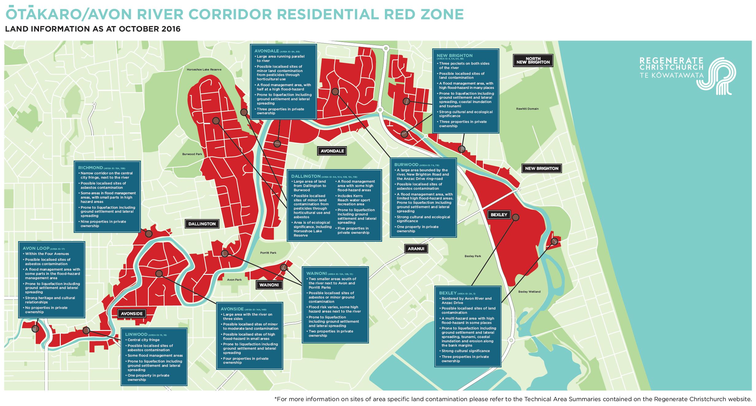
Regenerate Christchurch – Land Information
https://engage.regeneratechristchurch.nz/information-about-the-land/documents
Each document includes:
Overview of Residential Red Zone, Natural Environment, Waterways, Groundwater, Coastal Marine Area, Public Facilities, Reserves, Mana Whenua/Ngāi Tahu Interests, Archaeology and Heritage, Special or Other Features, Coastal Hazards, Flooding, Geotechnical, Contamination, Wastewater, Water Supply, Stormwater Management, and Transport.
– Southshore – Area ID:1
– New Brighton (Admirals Way and Evans Avenue) – Area ID:2
– Bexley – Area ID:3
– New Brighton (New Brighton Road) – Area ID: 4
– Avondale (east of Anzac Drive) – Area ID: 5A
– New Brighton (west) – Area ID: 6A, 6B
– Burwood – Area ID: 7A, 7B
– Avondale – Area ID: 8
– Burwood (east of Horseshoe Lake) – Area ID: 9A
– Burwood (Horseshoe Lake) – Area ID: 10A, 10B
– Dallington (north of McBratneys Road) – Area ID: 11A, 11B
– Dallington (south of McBratneys Road) – Area ID: 12
– Wainoni – Area ID: 13
– Avonside – Area ID:14
– Richmond – Area ID: 15
– Linwood – Area ID: 16
– Avon Loop – Area ID: 17
– Brooklands – Area ID: 18
– Ōtākaro Avon River corridor, Brooklands and Southshore residential red zones map
 Regenerate Christchurch – Flooding
https://engage.regeneratechristchurch.nz/flooding/documents
– District Plan floor level information
– Coastal hazards information
– New Zealand Coastal Society
– Flooding hazard provisions and mapping
– Historic ‘Black Maps’ of Christchurch showing waterways and swamps: Southshore
– Historic ‘Black Maps’ of Christchurch showing waterways and swamps: Avonside
– Historic ‘Black Maps’ of Christchurch showing waterways and swamps: Brooklands
– Historic ‘Black Maps’ of Christchurch showing waterways and swamps: Lower Avon